Pretty good apparently.
I recently carried out some model experiments using WRF to evaluate how our weather forecasts perform in terms of simulating the diurnal cycle of air temperature and humidity, which are the two key parameters determining heat stress experienced by humans – thanks to our collaborators at National Weather Service (NWS), San Diego.
The NWS provides daily weather forecasts using The Global Forecast System (GFS) for upto 16 days into the future at 0.25km spatial resolution, which can be freely downloaded from the following website:
https://nomads.ncep.noaa.gov/pub/data/nccf/com/gfs/prod/
While the GFS forecast is one key forecast product among several other weather forecasts adopted by the NWS, it is also typically used to drive regional climate models such as WRF at fine resolution using them as initial and boundary conditions. The GFS provides forecast over the entire globe but at a compromised coarse spatial resolution of 25km because of computational constraints. Thankfully, these data allows us to run regional model simulations at fine grid resolution, typically at 1-3km, suitable for making weather forecast and other climate studies on a local scale, which is more relevant to the public. Such fine resolution simulations better resolve the topographic and vegetation details and thus can provide better forecast on a city scale.
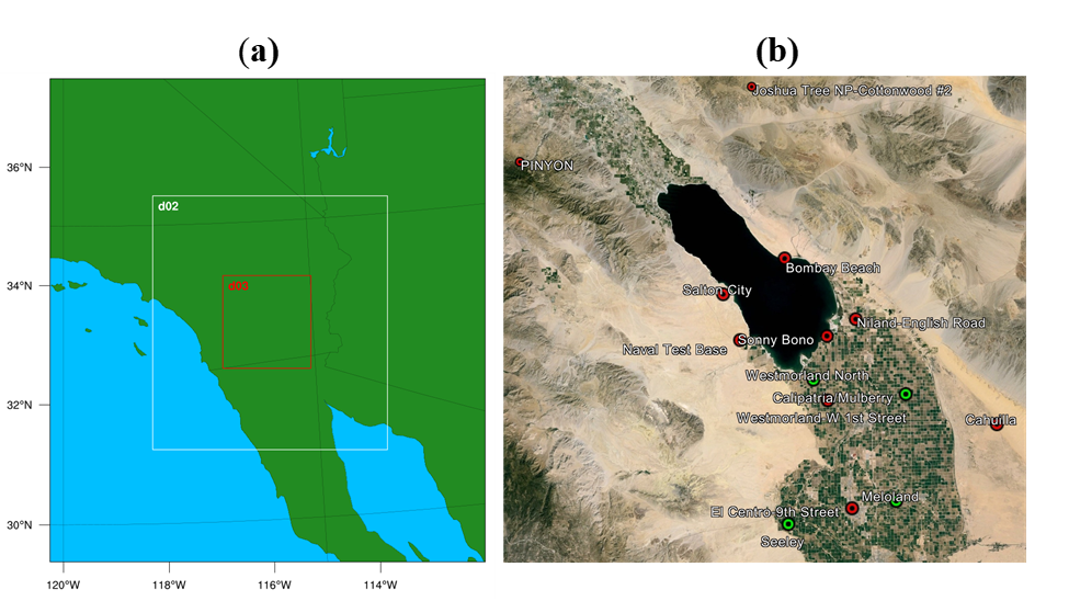
So here is what I did. I basically downscaled the GFS forecast (GFS-25km) using my WRF set-up over the Imperial Valley at 1km resolution and compared the downscaled results with the observations for a recent time period.

I also conducted another set of simulations by using ERA5 reanalysis (ERA5-WRF) instead of using GFS forecast (GFS-WRF). ERA5 reanalysis, which is also a global product at 31km resolution, is not a forecast but a hindcast with a 5-day latency. These reanalysis data are nothing but similar model results calibrated using actual observations so they are supposed to be more accurate.
I compared the above two sets of downscaled results from WRF and the original 25km GFS results with the actual observations recorded at four of our recently installed stations in the Imperial/Coachella valleys. Basicallly, the idea was to see if there is any value of running a high-resolution model at 1-km resolution, instead of just using the original forecast at 25km spatial resolution.


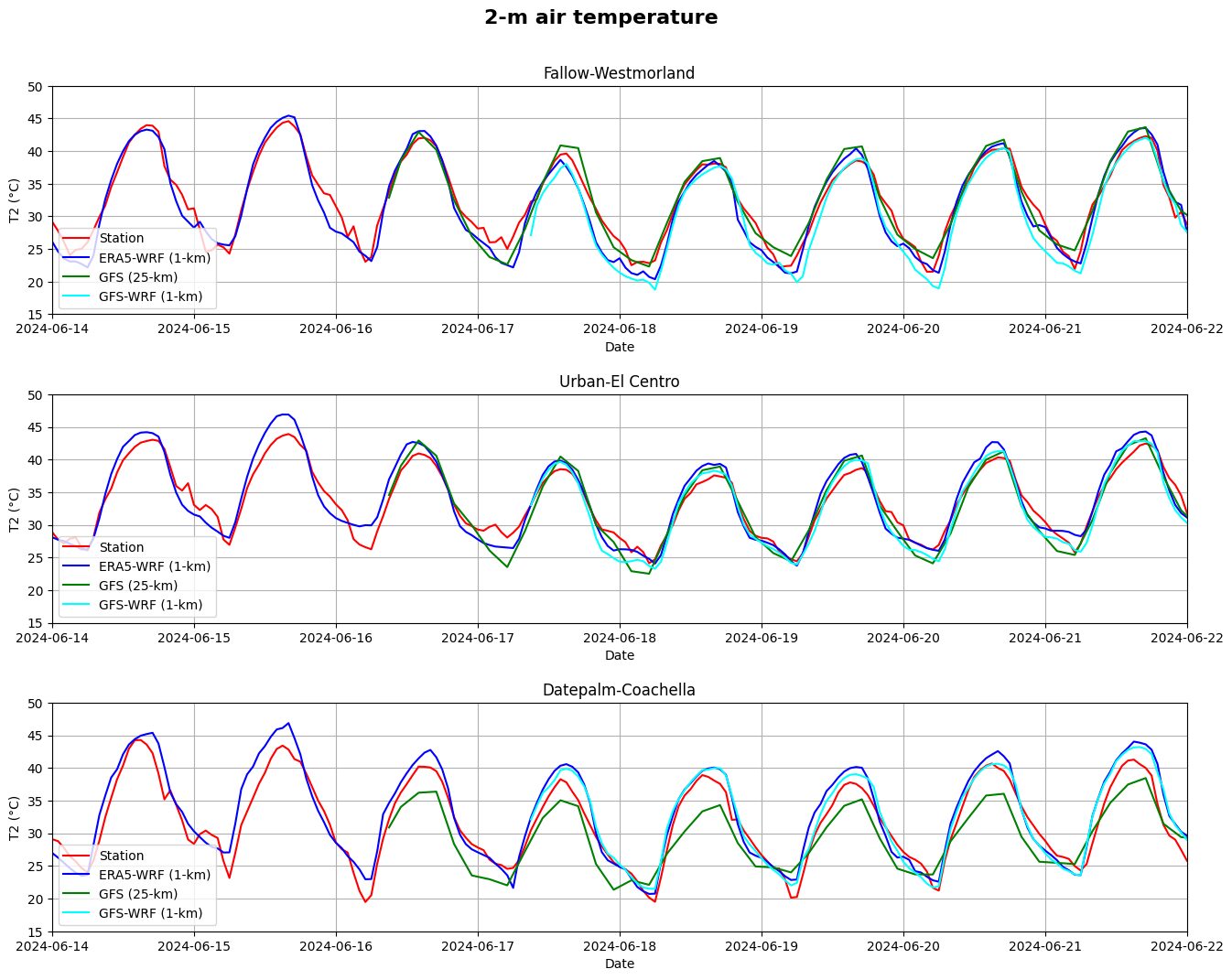
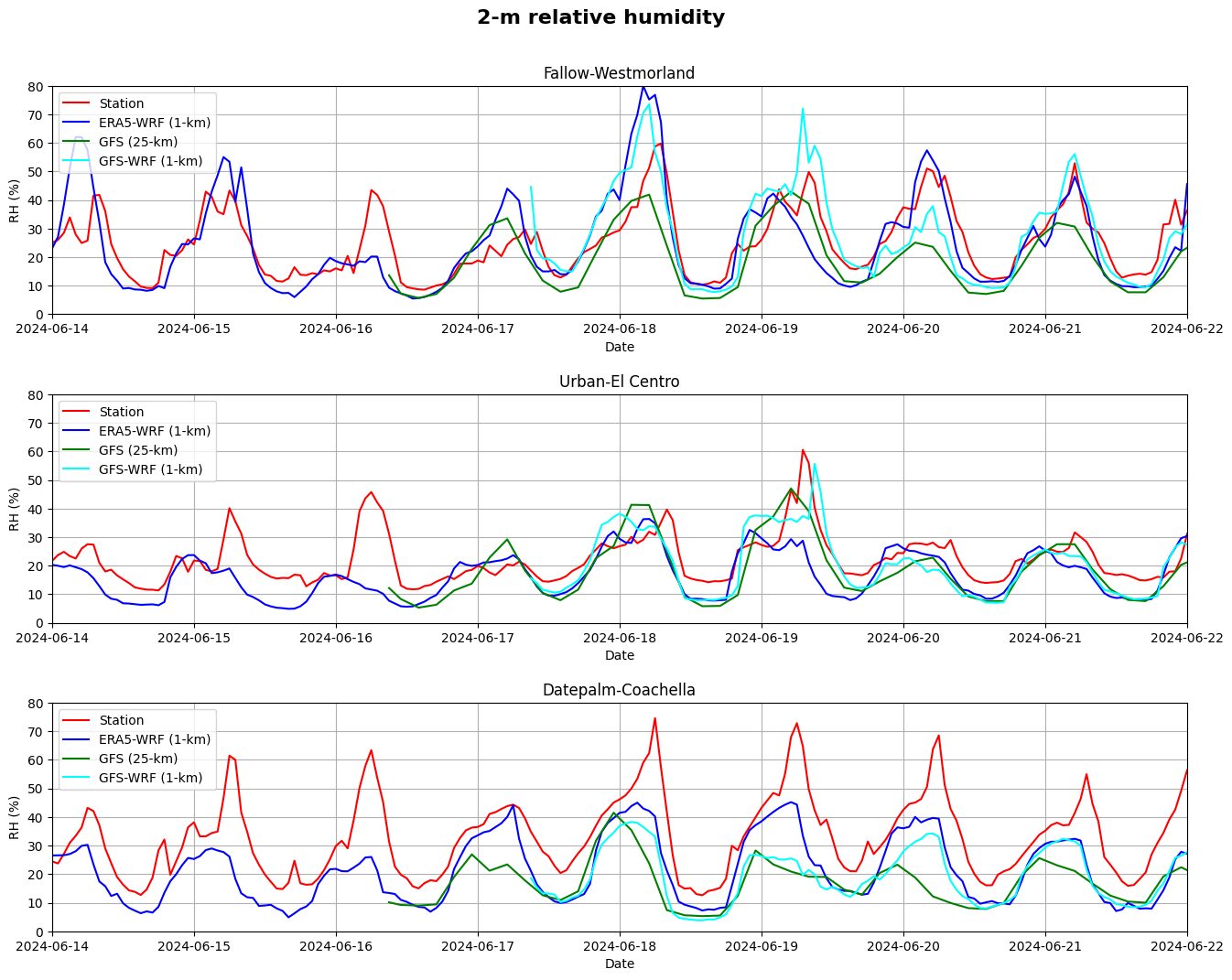
Above I show two figures comparing the above four sets of results in terms of 2m air temperature and 2m relative humidity. Here are my key takes from these results:
– The diurnal cycle of air temperature is simulated quite well by the 25km GFS forecast in the Imperial Valley region and WRF downscaling doesn’t seem to add much value.
– The performance of GFS-WRF is comparable to the ERA5 although the latter assimilates observations. The European Centre for Medium-Range Weather Forecasts (ECMWF) also provides similar forecast product at 25-km resolution but they require paid subscription. So, GFS forecast is a clear win here.
– There is some added value of WRF downscaling in the Coachella date palm region, where vegetation is taller. The GFS forecast underestimated the temperature but WRF did a much better job. This makes sense because tall vegetation clearly plays a strong role in this region in modulating the local weather, whose effect becomes more apparent at higher resolution.
– In terms of humidity, it seems to be a major challenge in forecasting. WRF downscaling appears to improve it somewhat but there is a lot to work upon in terms of getting the humidity right.
– Interestingly, the GFS forecast performance does not seem to downgrade with the forecast lead time as one would generally expect. The longer the forecast time into the future, less the reliability of the forecast because the model results depends upon the accuracy of initial/boundary conditions which become more uncertain as we go into the future. As a matter of fact, forecasting diurnal cycle is easier for models because they have repetitive patterns. The main challenge for our weather and climate models is to simulate the non-repeating weather and climate events such as extreme events.
As extreme events (e.g., extreme heat, extreme precipitation, extreme air pollution) are becoming more frequent, prediction of which is much more important to the society, comparisons in terms of extreme climate would be more meaningful. However, such evaluation requires multi-year simulations, and thus requires much more resources, time and effort, which is beyond the scope of this simple investigation.
Thank you for your time.


Leave a Reply